

The Legacy of the Kumeyaay: Their Road from Despair to Success
The San Diego Metropolitan Area
The San Diego Metropolitan Area is located along the Pacific Coast in the southwest corner of the United States and just north of the Mexican border. As of the 2020 census, the population of San Diego was 3,298,634. As a result, it is the second-most populous county in California and the fifth-most populous in the United States. According to Philip R. Pryde (ed.), San Diego: An Introduction to the Region (Dubuque, Iowa: Kendall/Hunt Publishing Co., 1976), p. 5:
San Diego considers itself the “birthplace of California.” It was the first part of what is now the state of California to be explored by Europeans, and the first to be colonized. Although San Diego was not settled by Europeans as early as were many East Coast areas, its history is at least as rich. Home to four major cultures (Indian, Spanish, Mexican, American), a succession of explorers, missionaries, governors, overland traders, and land promoters all arrived here early and left their marks, nearly eliminating in the process the Native Americans who had known the land for centuries before. [1]
However, in an article in The San Diego Union-Tribune, August 21, 2020, Samuel Q. Brown paid tribute to the earliest-known inhabitants of San Diego:
Set on the U.S.-Mexico border and nestled between the coast, deserts and mountains, San Diego is not only diverse in topography but also a melting pot for many different cultures. But it is too often forgotten as the ancestral home to the Kumeyaay Nation. The Kumeyaay (Ipai-Tipai-Diegueño) people have occupied San Diego and Imperial Counties for more than 12,000 years. Prior to European immigration, the Kumeyaay Nation was spread over the California and Mexico border. Currently, the Kumeyaay Nation is split between 13 small U.S. Kumeyaay Indian reservations in California, such as the Viejas Band of Kumeyaay Indians, and four Kumiai Indio tribal community ranches in Baja California, Mexico.
The Long-Term Residents of San Diego
Richard I. Carrico, in Strangers In A Stolen Land: American Indians in San Diego, 1850-1880 (Sacramento, California: Sierra Oaks Publishing Company, 1987, page 5) added that “a combination of temperate climate and a varied environment from coastal seashore to rugged mountains attracted prehistoric people [to San Diego] at a very early date.” As a result, the San Diego area “lays claim to the most ancient remnants of these early people.” More than 10,000 recorded sites span at least seven millennium, possibly back 12,000 years. “Historic San Diego left a rich legacy of rock paintings, bead work, stone architecture, finely worked tools, and other material culture that comprises an unparalleled prehistoric record.”[2]
It is important to remember that several Indigenous groups inhabited the San Diego region and the nearby adjacent regions to the north, east, and south. The following map by Ken Hedges in “Notes on the Kumeyaay: A Problem of Identification,” from The Journal of California Anthropology (Vol. 2, Issue 1, 1975), page 72, reveals the presence of Luiseño, Cahuilla, Serrano, Cupeño, Quechan, and other Indigenous groups that existed in the same region as the Kumeyaay (or Dieguiño):
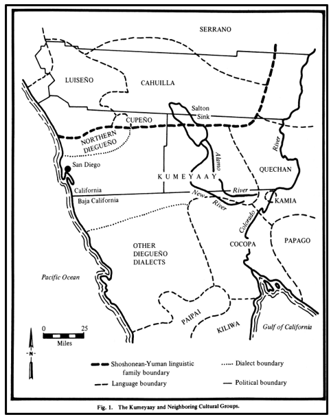
Map of the Kumeyaay and Their Neighboring Cultural Groups
Ken Hedges, “Notes on the Kumeyaay: A Problem of Identification,” The Journal of California Anthropology (Vol. 2, Issue 1, 1975), page 72, Figure 1.
The Kumeyaay Through Time
Evidence of the settlement in what is today considered Kumeyaay territory goes back about twelve millennia. The Kumeyaay are believed to have lived in San Diego since 10,000 B.C. After 1769, during the Spanish Colonial Period of California, the Kumeyaay were known as the Diegueños, a name that the Spanish authorities applied to the Mission Indians who lived in the area of the San Diego Mission. The Kumeyaay are referred to as Kumiai in Mexico. The term Kumeyaay translates as "People of the west", with the word meyaay meaning "steep" or "cliff".
The Language of the Kumeyaay
All languages and dialects spoken by the Kumeyaay belong to the Delta–California branch of the Yuman Language Family, to which several other linguistically distinct, but related, groups also belong (including the Cocopah, Quechan, Paipai, and Kiliwa). According to Margaret Langdon, who is credited with doing much of the early work on documenting the language, the general scholarly consensus recognized three separate dialects:[3]
Ipai (Northern Diegueño)
Kumeyaay Proper (Kamia)
Tipai (Southern Digueño) in northern Baja California
The bulk of the Kumeyaay primarily consisted of two related groups, the Ipai and Tipai. The traditional homeland of the northern Ipai extends from Escondido to Lake Henshaw (70 miles northeast of San Diego). South of the San Diego River, the Tipai occupied the Laguna Mountains, Ensenada and Tecate, extending well into northern Baja California. After the Spaniards occupied the San Diego Region, they referred to the Kumeyaay collectively as the Diegueño (after the San Diego Mission). The Americans continued the use of the word.
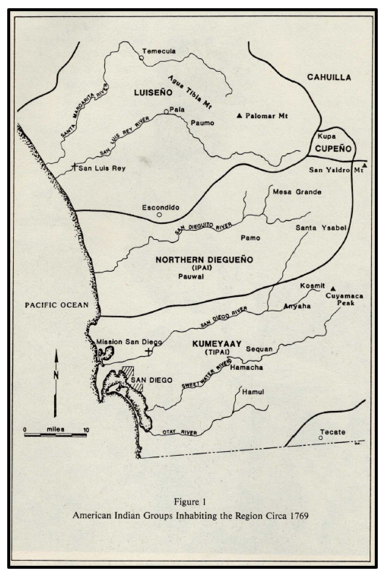
When the San Diego Presidio was established in 1769, it was founded in the territory of the Kumeyaay. The following map shows the Native American tribal groups that inhabited the San Diego region around 1769 when the first Spanish expedition landed there. It has been reproduced from Richard L. Carrico, Strangers in a Stolen Land (1987), Figure 1, page 12, showing the range of the Kumeyaay and Luiseño territories in 1769, at the point of the Spanish contact:
The Yuman (or Hokan) Language Group
The Hokan (or Yuman) Language Group has had a long presence in California and was spoken mainly in California, Arizona, and Baja California. The geographic distribution of the Hokan languages in California shows a broken chain of Hokan language islands around the margins of California. It seems likely that they were separated by the influx of later-arriving Penutian speakers. Included with the Kumeyaay in the Yuman branch are the Paipai, Kiliwa, Cocopa, Mohave, Maricopa, Quechan, and Yavapai. The Hokan language group is wide ranging, covering almost all of Baja California and some of the coastal lands of southern California. It includes tribes as far north as the Kurok of Northern California. The following map shows the range of the Hokan Languages at the time of contact:
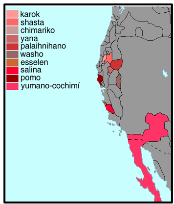
The Range of Hokan Languages at Contact
Map Source: Langs_N.Amer_espanol, Hokan Languages (2009). Online: https://commons.wikimedia.org/wiki/File:Hokan_languages.png.
Kumeyaay Territory at the Spanish Contact
The traditional Kumeyaay territory originally extended from around Escondido in California to south of Santo Tomás in the northern part of the present day municipio of Ensenada in Baja California. According to Hedges (1975: 21), the Kumiai (Kumeyaay) Indians inhabited an area that extended from the Pacific Ocean to the eastern part of the Imperial Valley, and from the central part of San Diego County about sixty miles south to Ensenada and Santa Catarina in northern Baja California. They were hunters, gatherers, and fishers. The term Kumeyaay is believed to mean “westerner,” which, in this context, probably refers to a people who lived west of the Colorado River.
The Population of the Kumeyaay at Spanish Contact (1769)
At the time of European contact (1769), the Kumeyaay comprised several autonomous bands with thirty patrilineal clans.[4] In 1925, Alfred L. Kroeber proposed that the pre-contact population of the Kumeyaay in the San Diego region in 1770 had been about 3,000.[5] However, more recently, Katharine Luomala has pointed out that this estimate depended on calculations of rates of baptisms at the Mission, and as such “ignores the unbaptized.” She suggests that the region could have supported 6,000–9,000 people.[6] Florence C. Shipek goes further, estimating 16,000–19,000 inhabitants. The following map created by Mike Connoly shows the range of their territory superimposed by the current boundary with the United States and Mexico.
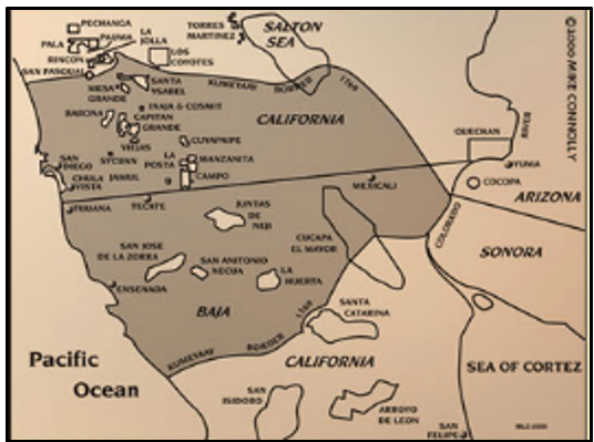
The Kumeyaay Territorial Boundaries in 1769.
Map Source: Mike Connolly, “Kumeyaay Map” (1769). Online: http://www.kumeyaay.info/kumeyaay_maps/kumeyaay_map.html.
While southern California Indian Nations shared many characteristics, they were not uniform in language, customs, political and social organization, or economic development. The Kumeyaay people planted trees and fields of grain, grew squash, beans and corn, gathered medicinal herbs, dined on fresh berries and pine nuts, fished and hunted deer, and were famous for their basket work. They instituted sophisticated practices of agriculture and plant husbandry, maintained wild animal stocks, controlled erosion and overgrowth, built dams, created watersheds and stored groundwater. [7]
The Governorship of the Kumeyaay
The Kumeyaay Nation was a federation of autonomous, self-governing bands with clearly defined territories that included individual and collective properties of families. The Kumeyaay united in defense of their territory and had a courier system of runners for communicating information throughout their lands.[8] They were governed by a social, political, economic and religious hierarchy led by the Kwaaypaay. A Kwaaypaay was usually the male head of a shiimull. He inherited the position from his father, but was not necessarily from the band he led. Kwaaypaay succession and leadership drew from among the sons of all Kwaaypaay, with the final choice requiring band approval. The bands were composed of the shiimull, or ancestral descent groups. The shiimull often had family loyalties that extended beyond the band. In 1769, when the Spanish arrived, between 50-75 shiimull existed, with 5-15 such family groups in each band.
In her Ph.D. thesis for U.C. Riverside, Strategies for Survival: Indian Transitions in the Mountains of San Diego County, 1846-1907, pp. 83-84, Dana Ruth Hick Dunn explained why the Europeans had a tendency to put their towns so close to native villages:
All around the city of San Diego and its outskirts, there were Indian villages that had been there before Europeans arrived. Indians chose these places because they were the most favorable areas for residing and contained food and water resources. These village areas were strategically placed according to ancient survival strategies that Indians used prior to European invasions. Indian residents of these villages were accustomed to moving about freely on their own lands and between villages. When Europeans arrived, they typically placed their towns next to Indian villages because of the abundant resources that Indians had already discovered there. From an Indian point of view, European intruders placed cities, towns and ranches in the center of Indian thoroughfares often obstructing and obliterating their survival resources.
The following map shows many of the major Indian villages located in San Diego County. The people in these villages would have been missionized by the San Diego and San Luis Rey missions. This computer-enhanced version of an original hand-drawn map is on file in the Florence C. Shipek Collection, Kumeyaay Community College Archives.
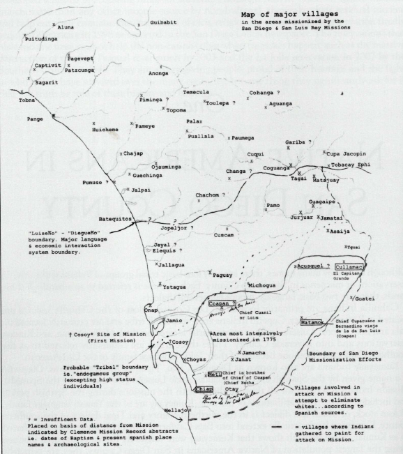
The Major Villages of San Diego County in the Early Years.
Source: Donna Bradley, Images of America; Native Americans of San Diego County (Charleston, S.C.: Arcaida Publishing, 2009), page 12 [From the Florence C. Shipek Collection, Kumeyaay Community College Archives].
The Expeditions of 1769
In 1769, five groups of Mexican-Spanish soldiers departed from Baja California and headed north for San Diego. Three groups traveled by sea while two others traveled by land in mule trains. Three galleons, hastily built in San Blas, set sail for San Diego in early 1769. All the expeditions were united in San Diego on July 1, 1769. On July 16, the Mission San Diego de Alcalá was founded, to be followed in the next 54 years by a chain of twenty more missions stretching northward through Alta California to present-day Sonoma. The mission was ceremonially established by the erection of a cross and celebration of mass on a great hillside overlooking the ocean. The party attempted to attract the attention of local Indians by hanging bells in the trees and putting out token gifts, but the Indigenous inhabitants stayed away.
Destructive Forces Unleashed
According to Carrico, Richard L. Strangers In A Stolen Land: American Indians in San Diego, 1850-1880. Sacramento, California: Sierra Oaks Publishing Company, 1987, “with the arrival of Spanish soldiers and missionaries in San Diego, destructive forces were unleashed upon the native peoples of San Diego… The arrival and settlement of Spaniards disrupted the social, economic, and cultural structure of the Indians, especially those who lived near the coast or at the mission sites. In the ensuing years, the affected native population was reduced by disease, conflict, and emotional abuse, sometimes intention and other times unconscious... European diseases took a terrible toll among the highly susceptible natives, causing a decline in the birth rate, a tremendous increase in deaths by disease and upsurge in the incidence of crippling and debilitating illnesses.” [Carrico, p. 12]. “The Spaniards brought with them cattle, horses, and sheep, animals that over-grazed lands, making them less suitable for foraging and gathering. The animals destroyed an important segment of the Indian economy and the subsistence pattern thus causing starvation.” [Carrico, p. 14].
The San Diego Mission is Moved (1774)
In 1774, the San Diego Mission was moved across and up the valley six miles inland to a better location in Mission Valley. The San Diego Presidio, with a military force of thirty men, remained on the commanding hillside. By December 31, 1774, the San Diego Mission and Presidio had nineteen families with a total of ninety-seven persons. During these early years, relations with the local Indians remained very poor.
The Revolt of 1775
By 1775, the priests at San Diego were able to convert and baptize almost 400 natives. This success most likely made the indigenous leadership feel threatened by the intruders. Believing the priests to be potentially dangerous shamans, on the night of November 5, 1775, approximately six hundred Indians from at least fifteen local villages attacked and burned the San Diego Mission to the ground. The entire Spanish force at the mission was only 11 men at the time. Father Luís Jayme was among the three killed. The following illustration shows the killing of Father Jayme.
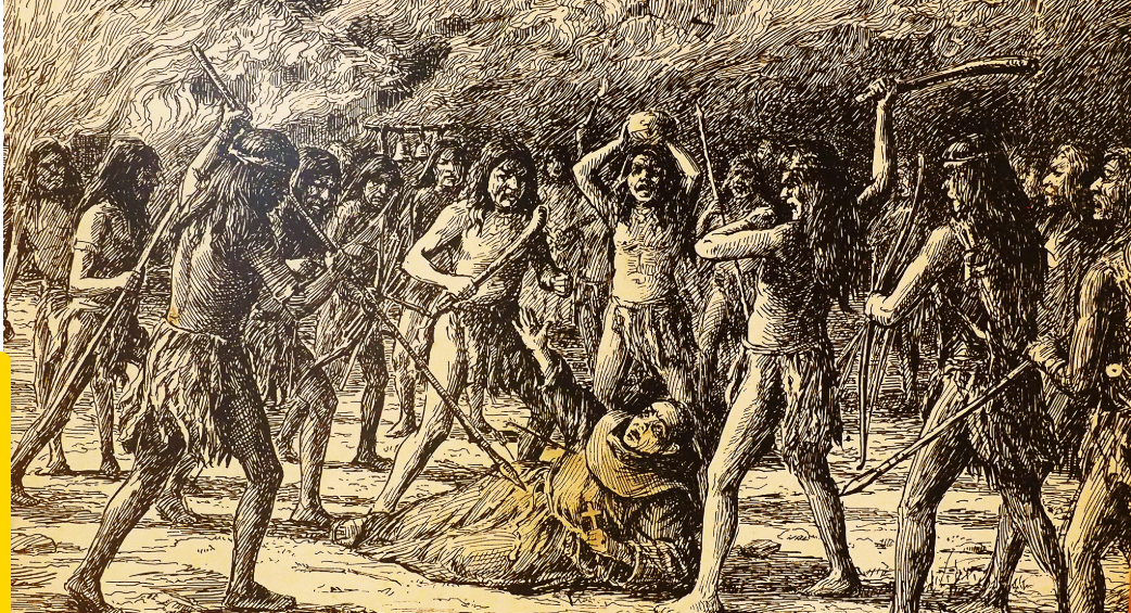
This illustration depicts the killing of Father Luís Jayme during the 1775 attack on the mission in San Diego (from Wikipedia Commons).
The survivors fought off the attackers. Fearing reprisals from the soldiers at the nearby presidio, the Indians did not press their advantage and instead fled into the interior. After this, most indigenous rebellions in the area were localized as the Indians recognized the Spaniards' superior weaponry. From this point, Kumeyaay resistance frequently took the form of non-cooperation (in forced labor), return to their homelands (desertion of forced relocation), and raids on mission livestock.[9]
With hostile Indians on the outside, and a scarcity of supplies arriving from San Blas, life was – at best – difficult for the Spaniards. According to Iris Engstrand, in Serra’s San Diego: Father Junipero Serra and California’s Beginnings:[10] “Rations were always scarce and the wives of soldiers made tortillas from the small supply of corn for their own families and the single men. Beans and sometimes a little fish or meat supplemented the meager diet. Crops were planted near the river with hopes for more abundant provisions.” By 1779, ten years after the founding of Mission San Gabriel, Mary Null Boulé, the author of Native American Tribes: Ipai-Tipai Tribes (Diegueño), wrote that there were 1,405 mission Indians living near the San Diego Mission. More would join the Mission System and by, the mid-1850’s, there would be about 2,500 tribal members.
Enslavement of the Kumeyaay
The local mission was expected to supply the army with food and livestock. The mission was also responsible for providing Indian labor for the settlers in the mission pueblos. Kumeyaay coastal land was confiscated for mission property. The people were captured and forced to work for the Spanish invaders. Soldiers scoured the countryside for Indians and brought them to the mission to be baptized and converted. In this way, the Kumeyaay provided a rotating labor force for food production, construction, and care of the livestock.
After a period of indoctrination and servitude, they were released to return to their homes. Only unmarried girls, the sick, some elderly, and Indians trained as craft specialists – leatherworkers, carpenters, and blacksmiths – were fed and kept at the mission. To avoid capture, many Kumeyaay fled to the mountains to make new homes or escape Spanish soldiers. Soldiers named Viejas Valley, “Valle de las Viejas, or Valley of the Old Women” after fleeing Kumeyaay. When searching the valley for native laborers, they found only old women living in the caves. The men and their families had escaped, leaving behind only older women who couldn’t keep up.
The Kumeyaay from 1798 to 1822
In 1798, Spanish mission lands expanded more into the Kumeyaay homeland, driving the Kumeyaay farther inland. The map below shows the extent of Kumeyaay lands in 1822, as well as the maximum extent of Spanish control at the time of Mexican independence.
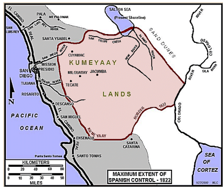
The Kumeyaay Territory in 1822 and the Maximum Extent of Spanish Control
Source: Richard L. Carrico, “Sociopolitical Aspects of the 1775 Revolt at Mission San Diego de Alcala,” The Journal of San Diego History, San Diego Historical Society Quarterly, Summer 1997, Volume 43, Number 3.
According to Richard L. Carrico, the years from 1769 to the Treaty of Guadalupe Hidalgo in 1848 “saw a rapid decline in the coastal Indian population, movement and abandonment of villages, disintegration of moral fiber, and cultural chaos. The Indians were forced into a marginal existence in a land that had previously provided an ample supply of food and resources.” [Carrico, p. 14].
First Mexican Empire and First Mexican Republic Period
The Mexican Empire – followed soon after by the Mexican Republic -- assumed ownership of Kumeyaay lands after defeating Spain in the Mexican War of Independence in 1821. The following year, Mexican troops confiscated all coastal lands from the Kumeyaay in 1822, granting much of the land to Mexican settlers (known as Californios) to develop the land for agriculture. This became known as the California Rancho Era.
The Kumeyaay fell victim to smallpox and malaria epidemics in 1827 and 1832, reducing their population considerably. Various disputes culminated into a skirmish between the Kumeyaay and Mexican soldiers stationed in San Diego in 1826, killing 26 Kumeyaay. This provoked Lt. Juan M. Ibarra to lead several attacks on Kumeyaay-controlled lands and killed 28 people in his attack on Santa Ysabel on April 5 of that year. According to the Campo-Kumeyaay website history map of Mike Connolly Miskwish, the Kumeyaay responded to Mexican attacks by launching their own attacks against the Mexican settlements from 1836 to 1842, as noted in the following map.
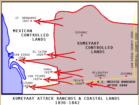
Mike Connoly Miskwish, “Kumeyaay Attack Ranchos and Coastal Lands, 1836-1842.” Online: https://www.kumeyaay.info/kumeyaay_maps/kumeyaay_mexico_1930s.html
Secularization of the San Diego Mission
Secularization of the San Diego Mission took place from 1834 to 1836. The Mexican Government confiscated church properties, exiled Franciscan friars, and divided the land. Though originally intended for Indigenous neophytes, the land and livestock were primarily seized by corrupt officials and settlers, leaving the mission in ruins. Although the original intention of secularization was to return the land to the Indigenous people, the San Diego mission lands were divided up by the Mexican authorities and given to wealthy Californios to build political loyalty, directly encroaching on Kumeyaay territory.
As a result of secularization, Julia Logan Bourbois, in her 2016 Pd.D. thesis, The Complexities of Labor: A History of San Diego Indians, 1770-1920, page 76, wrote the following about the affect of secularization on the Indians of San Diego:
In 1834, Indians formerly employed by the Missions transferred their labor expertise to the ranchos or the developing urban space of the San Diego Township. The development of the ranchos incorporated greater numbers of Indians as temporary and daily laborers in primary and secondary occupations associated with the ranch economy. Therein, San Diego Indians continued to employ horsemanship and raising livestock, the very skills in demand on ranches, to support their own economies and subsistence strategies.
According to Narcisco Dúran, “Secularization of the Missions” [from Digital History ID 540], by 1846, mission land and cattle had passed into the hands of eight hundred private landowners (known as the rancheros) in California. The rancheros controlled eight million acres of land in California. These ranchos, which mainly produced hides for the world leather market, relied heavily on Indian labor.
Many Kumeyaay Flee to the East
Many Kumeyaay individuals who had been institutionalized in the missions were forced to work as peons on these new private ranchos. They were often subjected to debt peonage, bounding them to landowners through advances on wages or food. However, many more Kumeyaay fled inland and reclaimed their freedom. Fleeing to the mountains or to the interior deserts (of what is now Imperial County), many of them rebuilt their communities in new locations. Many of them were then able to return to the traditional ways of life. However, there were escalating clashes with Mexican soldiers sent to subdue the Kumeyaay.
The San Pasqual Pueblo
Under Governor Jose Figueroa, the Mexican Government began to resettle the displaced Mission Kumeyaay. The pueblo of San Pasqual was established on November 16, 1835. Mexican officials chose Kumeyaay from Mission San Diego to settle the new community, which was along the Santa Ysabel Creek where Indians lived prior to the Spanish conquest.
Over time, the pueblo became a flourishing agricultural village under Jose Pedro Panto, the “captain” of the band. Its strategic positioning also served as a barrier against hostile attacks from other bands to the east. They partnered with Mexican ranchers, and protected ranchers from other native bands. In 1837, the Pueblo fought against hostile bands and protected Mexican settlers, with a decisive victory over an anti-Christian uprising and capturing its leader, Claudio. The Kumeyaay San Pasqual Indians who re-settled the San Pasqual Valley numbered 81 men, women, and children. The people who were chosen to develop the pueblo had an “impressive array of skills.” [11]
Although Mission San Diego provided the original population, over time, other Kumeyaay, possibly from Mission San Luis Rey, as well as unconverted people, joined them. A report by Mexican provincial officers in 1845 noted that San Pasqual comprised “sixty-one Christian souls, and forty-four unconverted Indians, with dwellings after their manner, huts of tule forming a kind of irregular Plazuela” Glen Farris, in “Captain Jose Panto and the San Pascual Indian Pueblo in San Diego County, 1835-1878,” The Journal of San Diego History, San Diego Historical Society Quarterly (Spring 1997, Volume 43, Number 2” provides a thorough history of San Pasqual that is accessible at: https://sandiegohistory.org/journal/1997/april/panto/
War Comes to California (1845-1848)
Tensions between the United States and Mexico had been growing, highlighted by various incidents taking place in both California and Texas. In the fall of 1845, President Polk sent his representative John Slidell to Mexico. Slidell was supposed to offer Mexico $25,000,000 to accept the Rio Grande boundary with Texas and to sell New Mexico, Arizona, and California to the U.S. However, the President of Mexico, preoccupied with internal dissension and suspicious of American intentions, refused to see Slidell. Slidell returned home, telling Polk that Mexico needed to be “chastised.”
In the meantime, Polk had ordered Major General Zachary Taylor, with 3,000 men under his command, to advance from the Nueces River to the Rio Grande. He reached the river in April 1846. A Mexican force crossed the river to meet him. On April 25, the small body of American cavalry was defeated by the superior Mexican force. This incident gave President Polk the pretext he needed. Claiming that Mexico had “invaded our territory and shed American blood on American soil,” he asked Congress to declare war. They did so on May 13, 1846.
Accounts of the War
Accounts of the Mexican-American War in California have been provided by Neil Harlow in his book California Conquered (published in 1982) and by Lisbeth Haas in her article, “War in California, 1846-1848” (which was published in Ramón A. Gutiérrez and Richard J. Orsi’s Contested Eden). Roy E. Whitehead, in Lugo: A Chronicle of Early California, discusses the war and politics that took place during this period on page 274 through 321. These sources should be consulted for a detailed account of the events that took place in California between 1846 and 1848. During the Mexican–American War, the Kumeyaay were initially neutral. The Kumeyaay of the San Pasqual pueblo were evacuated as the Americans approached the town. The Mexicans and the Californios were victorious over the Americans at the Battle of San Pasqual, but the Kumeyaay later sided with the Americans.
The Treaty of Cahuenga (1847)
On January 13, 1847, General John C. Fremont accepted Andres Pico’s surrender at the Treaty of Cahuenga, which ended the war in California. The articles of capitulation provided every citizen with the same rights as United States citizens. Californios were all guaranteed the protection of their life and property and the right to unhindered movement and travel, and the men pledged that they would not take up arms again for the duration of the war with Mexico.
The Treaty of Guadalupe Hidalgo (1848)
When the Treaty of Guadalupe Hidalgo was signed on February 2, 1848, Mexico handed over to the United States 525,000 square miles of land. The present states of California, Arizona, Nevada, New Mexico, Nevada, and Colorado were ceded by this treaty. In compensation, the U.S. paid $15,000,000 for the land and met other financial obligations to Mexico.
Of the treaty’s twenty-three articles, four defined the rights of Mexican citizens and Indian people in the territories. Californians were given the freedom to live in ceded territories as either American or Mexican citizens and their property was to be “inviolably respected.” Those Californians who chose to become Americans would be entitled to “the enjoyment of all the rights of citizens of the United States according to the principles of the constitutions.”
The Kumeyaay Territory Is Split in Two (1848)
After the Treaty of Guadalupe was signed, the Kumeyaay lands were split between the U.S. and Mexico when the border was drawn through the heart of Kumeyaay (Kumiai) territory. As noted in this map by Damien Bacich (CaliforniaFrontier.net), the Kumeyaay’s traditional territory spanned both sides of the present-day U.S.-Mexico border.
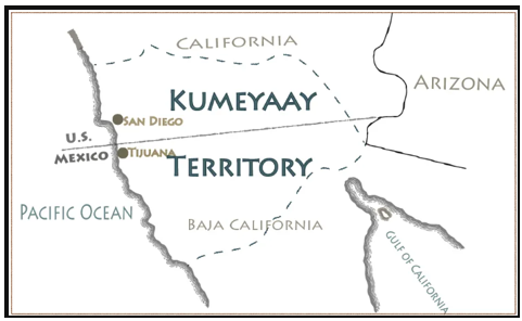
Map of Traditional Kumeyaay Territory Split after the Treaty of Guadalupe Hidalgo — by Damian Bacich / CaliforniaFrontier.net at “Native Americans of Southern California: The Kumeyaay.” at https://www.californiafrontier.net/the-kumeyaay/
The Betrayal And Broken Promises of the Treaty of Guadalupe
The 1848 Treaty of Guadalupe Hidalgo stipulated that property and religious rights would be respected and affirmed by title under American law. As citizens under Mexican law, these rights applied to the Kumeyaay/Mission Indians. The Kumeyaay and other Indians were friendly toward the Americans at first, hopeful that this new government would keep promises to settle the land disputes and treat the natives fairly. Prior to development of a state government, army officers were appointed as Indian subagents to see that peaceful Indians were not molested, and to prevent Indians from leading an “idle and thriftless life and encroaching on the peaceable inhabitants of the land.”
Taking advantage of the confusion over the legal ownership of church and Indian property as a result of Spanish and Mexican invasions, some agents acquired title to land owned by Indians. According to Carrico, Richard L. Strangers In A Stolen Land: American Indians in San Diego, 1850-1880. Sacramento, California: Sierra Oaks Publishing Company, 1987, “With the American takeover of California, the United States government ostensibly assumed control of California’s Indians immediately after statehood. In fact, the transition from a Mexican state to one of the American states left native peoples in limbo… California Indians were trapped into a destiny not of their own making.”
The Kumeyaay Join the Yuma War (1851)
In 1851, the newly formed San Diego County imposed a $600 property tax on local Native American tribes. Authorities threatened to seize land and property if the Indian tribes failed to pay. Chief Antonio Garra, who was educated at the Mission San Luis Rey, sought to unify the Cupeño, Kumeyaay, and Cahuilla tribes to fight back against this taxation and overall American expansion. This led to the San Diego Tax Rebellion of 1851 or "Garra's Revolt," beginning in November 1851 with the destruction of Warner's Ranch led by the Cupeño, opening up a new western front what was then known as the Yuma War (1850-1853). The Yuma War originally pitted the Quechan (then known as the Yuma) against the United States in Eastern California and Southwestern Arizona. By 1851, the Kumeyaay agreed to join the revolt alongside the Cahuilla, Cocopah, and Quechan warriors. However, the San Pasqual Band of Kumeyaay fought against the Quechan when they decided to attack San Diego and defeated the Quechan in the San Pasqual Valley.
The uprising ultimately failed due to a lack of broad tribal unity. Most notably, Juan Antonio, a influential Cahuilla leader, opposed Garra's methods. Juan Antonio captured Garra and turned him over to American authorities. Following a military trial in Old Town, San Diego, Chief Antonio Garra was executed by a firing squad at the El Campo Santo cemetery in December 1851.
Compared to other California tribes, the Kumeyaay did not face the same magnitude of destruction and exploitation under the so-called California Genocide. This was due to the strategic positioning of the Kumeyaay and the lack of gold in the mountains. Additionally, Mexican officials in Baja California Territory threatened to intervene in the conflict if they committed any atrocities on tribes along the border, due to a mix of Mexican sympathies towards the Native Californians and a fear of refugees coming across the border.
Negotiating Treaties with the California Indians (1852)
In 1852 federal authorities sent three commissioners to negotiate treaties with the 139 California Indian tribes and villages throughout the state. On January 5, 1852, the Treaty of Temecula was signed with the Luiseño and Cahuilla Indians of northern San Diego County. Two days later, on January 7, 1852, representatives of a number of Kumeyaay clans met with Commissioner Oliver M. Wozencraft and negotiated the Treaty of Santa Ysabel. Nearly 50 Southern California tribal leaders from Temecula, Santa Ysabel, San Dieguito, Sycuan, Jacumba, San Felipe and Vallecito attended. The “Peace and Friendship” treaties recognized federal authority.[13] The two treaties initially held some promise. In each case, the Indians were ceding large tracts of land, while securing for themselves a paltry number of acres. The Indians would also receive educational aid and a supply of livestock and dry goods.
In her Ph.D. thesis for U.C. Riverside, Strategies for Survival: Indian Transitions in the Mountains of San Diego County, 1846-1907, p. 131, Dana Ruth Hick Dunn wrote: “By 1852, Indians had seen the worst in what Euro-American intruders had to offer as adjoining residents. American squatters and multitudes of newcomers poured into the country looking for land titles. Indians experienced hostile vigilante groups and expeditions against them.” For this reason, the Indian leaders chose to sign the treaties as a “survival strategy.” Ms. Hick Dunn further acknowledged the threat that the Indigenous people were facing on page 141:
Indian reasoning for treaty signing as a survival strategy was understandable. Their lives were being threatened by military expeditions and by incoming Americans purchasing village land that the government had placed into the public domain, pushing them off their lands. Indians were being pushed further and further into distant valleys and mountains. City authorities did not allow Indians near the cities unless they were employed there. They were quickly losing their water, food and subsistence resources because of increased farming and ranching. Starvation was looming on the horizon. The American populace was threatening to remove them to another state and still others were threatening to exterminate them.
The Eighteeen Treaties (1852)
The agreements at Santa Ysabel and Temecula were part of the famous “18 Treaties” of California, negotiated to protect Indian land rights. In these treaties, the Indians agreed to refrain from fighting with other tribes and local whites in return for food, tools, and livestock. After the 18 Treaties were completed, the documents were sent to the United States Senate for approval. However, American settlers and the California congressional delegation opposed the creation of reservations, claiming that they would give away important mineral and agricultural lands. (In fact, the lands to be given to the Indians “were mostly barren and sterile, unfit for farming.”) Under pressure from white settlers and the California Senate delegation, the treaties were all rejected. In June 1852, the U.S. Senate rejected the treaties.[12]
Harry Kelsey, in “The California Indian Treaty Myth,” Southern California Quarterly 55 (Fall 1973), pp. 4-5, states that “in most of the cases, small bands or extended families were presumed to represent entire tribes, signing treaties that they were not authorized to sign, offered by commissioners.” One source stated, “Taken all together, one cannot imagine a more poorly conceived, more inaccurate, less informed, and less democratic process than the making of the eighteen treaties in 1851-1852 with the California Indians. It was a farce from the beginning to end.”
California Indian Laws
The law known euphemistically as “An Act for the Government and Protection of Indians” was enacted on April 22, 1850, about five months before California became the 31st state on September 9, 1850. Among other provisions, the act declared that an Indian could be declared to be a “vagrant” by the courts if it was perceived that he could not support himself, or if he was found “loitering,” or if he was leading an “immoral…course of life.” In addition, a white person could bring an Indian child before a court official. If the child’s parents agreed, or if his “friends” agreed, the court could make the white person responsible for the “care, …control, and earnings” of the child until the child became an adult. That meant until 18 if the child was a boy, and until 15, if a girl. Scholar Sherburne F. Cook concluded the following effect about this law:[13]
…any Indian, merely upon the word of a citizen, might be brought into court and declared a vagrant. Thereafter, he might be put up at auction and his services as a laborer sold to the highest bidder for a period not to exceed four months. No compensation, of course, was given, although the owner was expected to support the Indian. This act obviously made it possible for a native to be held not only as a peon, but as an actual slave, for any unemployed Indian could be proved a vagrant.
The Effect of the Apprenticeship Laws
The 1850 law was also known as the Apprenticeship Laws. This law made California Indian children “valuable possessions.” This had the effect of encouraging the kidnapping of them. As early as 1853, there is evidence in newspaper accounts that after hunting, attacking, and killing Indians, parties of local men would divide up the children to keep for themselves. In 1861, the Superintendent of Indian Affairs in California reported that a band of men were kidnapping Indian children in the northern coastal counties of the state, transporting them south and selling them as virtual slaves. The Superintendent believed this was a “crime against humanity,” and blamed the apprentice laws. He recommended that Congress outlaw the practice.[14] It is impossible to know how many California Indian children were kidnapped in this manner because the activity was often hidden from public view. Serious estimates put the number from 3,000 to over 4,000. There was an active market for Indian “apprentices” with a going rate of around $50.[15]
The Continued Decline of the Kumeyaay
When Chief Tomas of the San Pasqual band met with a government agent in June 1856, Tomas stated that he had witnessed a terrible deterioration of his people and expressed a feeling of hopelessness. Chief Tomas asked the agent what had happened to the 1852 treaties that he had signed. In the years to follow, Tomas and the San Pasqual Indians would be forced by local officials to abandon their ancestral lands.[16]
During this time, some of the Kumeyaay Indians in the San Diego area found employment as ship hands when San Diego became a port of call for schooners engaged in the flourishing whale trade. However, work was still difficult to find considering the fact that Indian laborers were paid one-third or less than the usual wage. At the same time, some Indian women found employment in domestic service. A steady influx of white settlers into San Diego threatened the few Indian holdings and the U.S. Government was unwilling to recognize any right of exclusive occupancy to any specific lands.” [17]
As the 1850s drew to a close, the Commissioner of Indian Affairs admitted that the previous ten years of effort had been less than successful and that “management of our Indian Affairs in California has been embarrassed with a great variety of difficulties. Neither the government of the United States nor the State of California recognizes in the Indians any right of exclusive occupancy to any specific lands.”[18] In 1860, the U.S. Federal Census tallied 2,692 Indians as living in San Diego County. However, it is believed that the actual Indian population was closer to 4,000.
The Civil War (1861-1865)
Abraham Lincoln became President in 1861 and had hoped to develop a new Indian policy, but the Civil War broke out, and the government priority turned to ending the Southern insurrection. Government agents were fearful that the Indians of San Diego would not remain loyal to the Union cause. However, the Indians of Southern California remained quiet throughout the war. In fact, the Wilmington Journal noted: “It is astonishing that these tribes have behaved so well considering the pernicious teachings they have received from vile secessionists in their midst.”[19] During the Civil War years, sentiment among the Caucasians towards the Indigenous people remained poor, partly due to compelling articles in the press [that were mostly false]. On July 7, 1862, the San Diego City Council ordered the sheriff to remove "Indian rancherias" one-half mile from any town residence. Some newspapers carried stories of Indian alcoholism, petty crimes, and unemployment.
The first large-scale contribution of goods to the San Diego Indians did not take place until May 1865 when 100 Ipai and Tipai led by the aged chief Tomas arrived in Temecula to meet with Cahuillas and Luiseños and received the first large-scale contribution to the welfare of the Indians of San Diego. It was reported that 1,400 Indians attended the meeting at Temecula, bringing with them a census of their population and accounts of their livestock and produce.[20]
Working Toward a Reservation System
For the better part of twenty years, reports from Indian agents and commissioners were filled with recommendations and plans for establishing Indian reservations in San Diego County. But these recommendations and plans fell on the deaf ears of congressional leaders. Indian agents continued to advocate the need for reservations to ensure that the farming activities of native people would continue and to protect them from the white settlers who always seemed to inhabit the fringes of native settlements. In 1867, Indian Agent John Stanley admitted that “the whites are pushing back on the frontier, and unless lands are reserved for the use of the Indians, soon they will have no place to live.[21]
Ulysses S. Grant Becomes President (1869)
Having been elected President on November 3, 1868, President Ulysses S. Grant assumed office in March 1869. He served as the 18th President of the United States from 1869 to 1877, having been re-elected for a second term on November 7, 1872. According to Carrico (page 63), “President Ulysses S. Grant and his advisers formulated and implemented his Indian Peace Policy. Grant sincerely believed that the Indians held a natural title of the land and that, to the Indian’s detriment, the military had dominated past Indian policies. Over the next several years, Grant instituted several reforms. Notable among them included establishing a Board of Indian Commissioners to disburse funds and establish reservations…”
In October 1869, First Lieutenant Augustus P. Greene, formerly of the U.S. Artillery Fourth Regiment, was appointed a special agent in Southern California. He estimated that he was responsible for almost four thousand Indians, half of which were Mission Indians. He explored areas that could be used as possible reservation sites. One of the sites chosen was the San Pasqual where about 150 Indians already lived in an old, established village. But many of these people were being crowded out by more and more white settlers. Greene noted there were some 2,000 acres of “potentially valuable agricultural land.” On January 6 1870, Greene’s report was submitted to President Grant, along with supporting letters from Major General John B. McIntosh, Superintendent of Indian Affairs for California, and others. [22]
Creation of the First Reservations (1870)
The rejection of the Treaty of Santa Ysabel had marked the beginning of an extremely difficult era for the San Pasqual Indians. Squatters and homesteaders poured into the San Pasqual Valley and surrounding region, the creek making the land highly desirable for farming and cattle rearing. On January 31, 1870, following recommendations from the Secretary of the Interior, President Ulysses S. Grant issued an Executive Order, establishing two reservations in Southern California. The two reservations covered some 138,000 acres in San Diego County, one at Pala for the Luiseños and the other at San Pasqual for the Kumeyaay’s. They were physically separate but considered one single reservation by the government.[23] The San Pasqual Reservation consisted of 92,000 acres.
Public Opinion Does Not Encourage “Needless Generosity”
However, popular opinion against the reservations remained strong. On March 10, 1870, an editorial of the San Diego Union stated that the government’s plan for a reservation was a terrible idea and a swindle that was needlessly generous to the Indians. The newspaper vowed to fight the reservation plan until it was rescinded. Another article in April stated that the reservation plans were actually “a devious land scheme.” The paper even claimed that an anti-reservation petition with 500 signatures had been sent to Washington, D.C.[24]
Special Agent Greene moved his agency office in April 1870 to San Pasqual, in order to better serve the 195 Kumeyaay Indians who lived at San Pasqual. Meanwhile, more than one hundred white squatters living in the valley, protested the establishment of the San Pasqual Reservation. But Greene, in a report, explained why so many whites were living on the San Pasqual Reservation. He explained that the intruders, upon learning of the recommendation to establish the reservation at San Pasqual, had rushed to the village, with the intention of trading and selling liquor to the Indians. Most of the whites had not intended to live permanently in the area. [25]
The San Pasqual Reservation Is Revoked (1871)
Due to non-Indian settler demands, however, the executive order establishing San Pasqual Reservation was revoked on February 17, 1871, returning the land to the public domain and forcing Indians from their homes. The revocation rendered the Kumeyaay, particularly those in the San Pasqual Valley, essentially homeless or forced them to squat on their own ancestral lands. However, local newspapers applauded the decision.
The Decline of San Pasqual (1874-1878)
Panto, the Chief of San Pasqual, died on April 27, 1874 at San Pasqual after being thrown from his horse. His obituary stated that “His [Panto’s] land at San Pascual had always been respected — and in fact did constitute a regularly organized pueblo — until within the past year or so. Now that Panto, who governed his people so well, is gone, it is believed that they will not linger long upon their old planting ground” [from the San Diego Union, 3 May 1874].
After Capitan Panto’s death, the Kumeyaay community at San Pascual declined at the hands of the white squatters. By 1878, the Indians of San Pasqual were summarily forced off their land by a deputy sheriff and other county authorities from San Diego and scattered to the hills or to other rancherias such as Mesa Grande. Some of the San Pasqual residents would find refuge with other Kumeyaay bands at Mesa Grande and La Jolla, or in the hills surrounding the ancestral valley. Other San Pasqual Indians journeyed to the surrounding towns to earn a living as best they could.
The San Pasqual people adapted themselves to the new world they were forced to live in, learning English and developing new skills. Many of them took Mexican or even Anglo spouses, adding to the cultural heritage of the community. In spite of these adaptations, band members maintained many of their social and cultural ties. Fiestas celebrating the saint’s day of San Pasqual were held at the pueblo’s original chapel or other Indian villages. Some maintained the traditional Kumeyaay language and cultural traditions.
The Kumeyaay Situation in 1875
By 1875, farming and ranching conditions for the Kumeyaay had deteriorated severely. They had lost so much land that public outcry about their treatment would eventually result in another Presidential Order. In November 1875, Chief Olegaria of the Luiseño met with President Grant and explained the situation of the San Diego Indians to him. Later, the San Diego Union stated that the President had “promised temporary relief to the ejected Indians, and said that he would recommend Congress to provide a permanent home for them.”[26]
President Grant Creates Multiple Reservations (December 1875)
As Richard L. Carrico stated, “President Grant, still in pursuit of his Indian Peace Policy and acting on the advice of local and federal agents, proved true to his word in contrast to past government officials. On December 27, 1875, he issued an executive order that set aside lands in San Diego County for the exclusive use of Native Americans.”[27] President Ulysses S. Grant created a large number of Southern California reservations on December 27, 1875, through a series of executive orders setting aside lands for the Mission Indians and setting their boundaries. These reservations included Santa Ysabel, Pala, Agua Caliente, Sequan, (Sycuan) Inaja, Cosmit, Potrero, Cahuilla, and Capitan Grande.
Of the nine small reservations created by President Ulysses S. Grant's Executive Order on December 27, 1875, seven were established for various bands of the Kumeyaay people, including Santa Ysabel, Pala, Sycuan (Sequan), La Jolla, and Capitan Grande. The remaining two reservations (Cahuilla and Agua Caliente) were established for the Cahuila and Cupeño peoples. In total, the Indians secured 52,400 acres and the government set aside another 6,000 acres for the Southern California Indians in May 1876. Through the later executive order, Grant added 640 acres to Potrero and 880 acres to Agua Caliente. Thus, “after years of adversity, Grant’s Peace Policy and Indian land reform finally arrived in San Diego County.”[28] The following map shows the San Diego County reservations that were established in 1875.
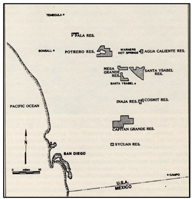
Map of the San Diego Native American Reservations Established in 1875.
Source: Map by Richard L. Carrico, Strangers in a Stolen Land, p. 85, Figure 3.
1877: A Year of Severe Drought
In 1877, a severe drought throughout San Diego County resulted in attacks on Indians who held water resources. In fact, on May 3, 1877, part of the land set aside for San Diego Indians by President Grant in 1875 was withdrawn from Indian use and restored to general settlement. The reservations owned by Indians dropped to approximately 60,000 acres in total. Then, on July 31, 1877, an outspoken advocate of the Indians, Chief Olegaria died. He had enjoyed the support of many tribal groups through the San Diego area.
1890: A New Dawn With Drawbacks
On January 17, 1880, President Rutherford B. Hayes issued an executive order, cancelling the almost one thousand-acre reservation at Agua Calientes (Warner Hot Springs) and removing nearly two thousand acres of the Santa Ysabel Reservation established in 1875. These lands were returned to the public domain at the request of several Anglo settlers.[29] However, on June 19, 1883, President Chester A. Arthur issued an executive order withdrawing an additional 120–acre local tract for "the permanent use and occupation of the Mission Indians in the State of California," specifically the Mesa Grande.
By 1890, according to Richard L. Carrico, “a new era had dawned for the Indian peoples.” Many natives had given up living in traditional settlements and many of them moved to reservations, while “others settled in white communities, attempting to acculturate into a new world.” Many outsiders saw the Southern California Indians as “dying culture” and a “vanishing race.”[30]
According to Richard L. Carrico, the failure of the 1852 treaties, the revocation of the 1870 Pala and San Pasqual reservations, and the frequently shifting boundaries of the reservations, “left Native Americans disillusioned with, and cynical about, the government.” With the exception of prostitutes, alcoholics, and “others caught up in the avarice that often developed on the American frontier, most Indians sought meaning and fulfillment in their own way of life at a time when appeasement and cultural distingration were far easier.” Most Indian leaders, in fact, tried to understand the American legal process and how they could work within it.[31]
The 1885 Indian Census
The annual Indian census rolls across the U.S. that we taken — starting in 1885 — were compiled by agents of the Bureau of Indian Affairs (BIA) and mandated by the Act of July 4, 1884 (23 Stat. 76, 98). The Act stated “that hereafter each Indian agent be required, in his annual report, to submit a census of the Indians at his agency or upon the reservation under his charge.” A directive in 1885 (Circular 148) told agents to show the Indian name, the English name, Relationship, Sex, and Age.
The 1885 federal Indian census listed 2,692 Native Americans in San Diego County, though the actual population was estimated closer to 4,000. The largest concentration was recorded in Temecula. The census counters went to nine of the reservations or rancherias associated with the Kumeyaay (Diegueño), specifically Santa Ysabel, Pala, Sycuan, La Jolla, Rincon, Viejas, Capitan Grande, Inaja, and Cosmit. The original 1885 returns for the San Diego Region are archived under the Mission Agency records and primarily include the Kumeyaay (Ipai/Tipai), Luiseño, Cupeño, and Cahuilla peoples living on local rancherias and reservations.
Some of the pages of the earliest Indian censuses, especially the headers, can be hard to read. For the 1886 Indian Census, the San Diego Indians, including Dieguiño, can be found on National Archives Microcopy 257 entitled “Mission Tule River (1886, 1888, 1890, 1893).” Two segments from the Capitan Grande pages shows us parts of the three pages dedicated to that reservation (Images 5 and 7 of 584) and the fact that Capitan Grande had 57 inhabitants in 1886.
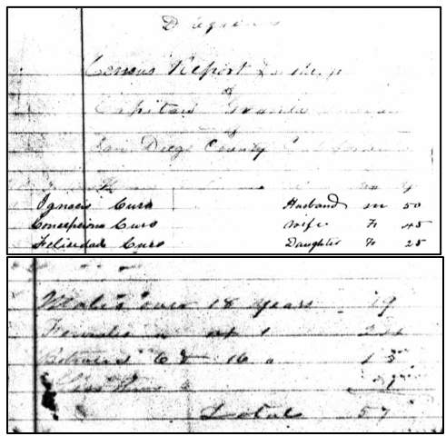
Portions of the 1886 Indian Census Extracted from National Archives Microcopy 257 (Mission Tule River, 1886, 1888, 1890, 1893), Images 5 nd 7 of 584.
After each reservation or rancheria was tallied, there was a page that summarized the number of people in each location. Other native San Diego communities included in the 1886 Indian Census and the number of their inhabitants were: San Pasqual Indian Village (48 inhabitants), Sycuan (51 inhabitants), Santa Ysabel Reservation (145 inhabitants) and San Ysidro (60). These people are listed on Image 5 through 59 on Microcopy 257 (National Archives Microfilm, Mission Tule River (1886, 1888, 1890, 1893).
The 1888 Indian Census
The 1888 Indian Census for the San Bernardino, Riverside, and San Diego county regions is more readable text and can also be seen on National Archives Microcopy 257 entitled “Mission Tule River,” (1886, 1888, 1890, 1893). The 1888 section begins at about Image 264 and continues to the tallies shown at the end (ending at Image 331). At Image 326, one can see the tallies of all the Indigenous tribes and the data on their numbers shown on the preceding pages.
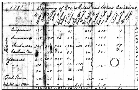
The Indian Census Tally for Southern California in 1888.
National Archives Microcopy 257 entitled “Mission Tule River, 1886, 1888, 1890, 1893), Image 326 of 684.
A few pages later, there was a count of Dieguiño Indians taken in the 1888 census. In all, there had been 415 Dieguiños listed in their communities, including 92 at Capitan Grande and 106 at Santa Ysabel. The Dieguiño tally for the 1888 census follows.
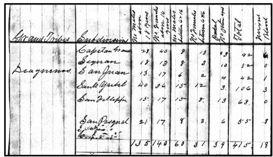
The Indian Census Tally for Dieguiño Indian Villages in 1888.
National Archives Microcopy 257 entitled “Mission Tule River, 1886, 1888, 1890, 1893), Image 326 of 684.
The Smiley Commission Report (1891)
On January 12, 1891, the U.S. Congress adopted the Mission Indian Relief Act of 1891 which established the Smiley Commission to report on the status of the Mission Indians of California. The Act created the commission to carry out the Act’s mandate. Section 2 of the Act provides: “It shall be the duty of” the California Mission Indian Commission “to select a reservation for each band or village of the Mission Indians residing within said State, which reservation shall include, as far as practicable, the lands and villages which have been in actual occupation and possession of said Indians, which shall be sufficient in extent to meet their requirements.”[32] The three men tasked with the job of reporting on the existing Indian villages went through one Indian village after another in San Diego and Riverside counties. They would establish, adjust, or confirm several scattered reservations in San Diego County.
The Commission recommended that a specific land area be set apart as a reservation to be called Mesa Grande. There were three families of Indians living on the land, but they did not wish to be moved to a larger reservation. The Inaja and Cosmit reservations were situated contiguously and had been set apart by an executive order dated Dec. 27, 1875. However, the Smiley Commission referred to their rancheria as being on “utterly worthless land,” and the land they had been cultivating was taken over by a white man. No Indians then lived on the Cosmit Reservation “because no one could live upon it.” Meanwhile, at Inaja, thirty Indians under Captain Jose Dolores had some seventy acres of arable land. About forty acres of the land was “good grazing land.”
The Rancheria at Campo consisted of “eight houses and forty-seven Indians. They had water and some good land and there is demand for work in the neighborhood.” At the same time, there were some forty Indians living at the Manzanita Rancheria. The report stated there was “very little land” and it was “a very poor quality” and that the Indians here were “the very poorest Indians of all visited.” Because “a larger amount of land had been reserved at Capitan Grand,” they hoped that many Manzanita Indian could be induced to remove to Capitan Grande.
The Sycuan Reservation was “well watered, and nearly all arable.” There were about fifty Indians on the reservation. The report noted that about one-sixth of the Capitan Grande lands were cultivatable lands. The rest of the lands were primarily grazing lands. The report indicated that the “reservation will make ideal homes for Indians.” They described the inhabitants of the reservation as “intelligent and good workers” There were about 150 Indians living on the reservation.
Thirteen New Reservations (1891)
The Smiley Commission report was submitted on December 29, 1891. In the end, the 102-page report recommended establishing or confirming Kumeyaay reservations for various bands, including Campo, Capitan Grande, Cosmit, Inaja, Manzanita, Mesa Grande, Santa Ysabel, and Sycuan. President Benjamin Harrison by Executive Order adopted the conclusions of the 1891 Smiley Commission on December 29, 1891. Thus, by the end of the year, at least 13 new reservations were established, home to some 650 people in total: San Manuel, Ramona (north of Cahuilla), La Posta, Manzanita, Cuyapaipe or Long Canyon, Campo, and Laguna, all in the mountains of southern San Diego County. Pauma and Rincon were established along the San Luis River. Also established were Augustine Reservation, Cabazon Reservation, Santa Ysabel, and Twenty-nine Palms. [33]
Photograph of Kumeyaay Natives (Unknown Date)
The following undated historical photograph of Kumeyaay natives was taken by Matilda Cox Stevenson (1849-1915), documenting the lives of the Kumeyaay people in San Diego. The photo is in the public domain.
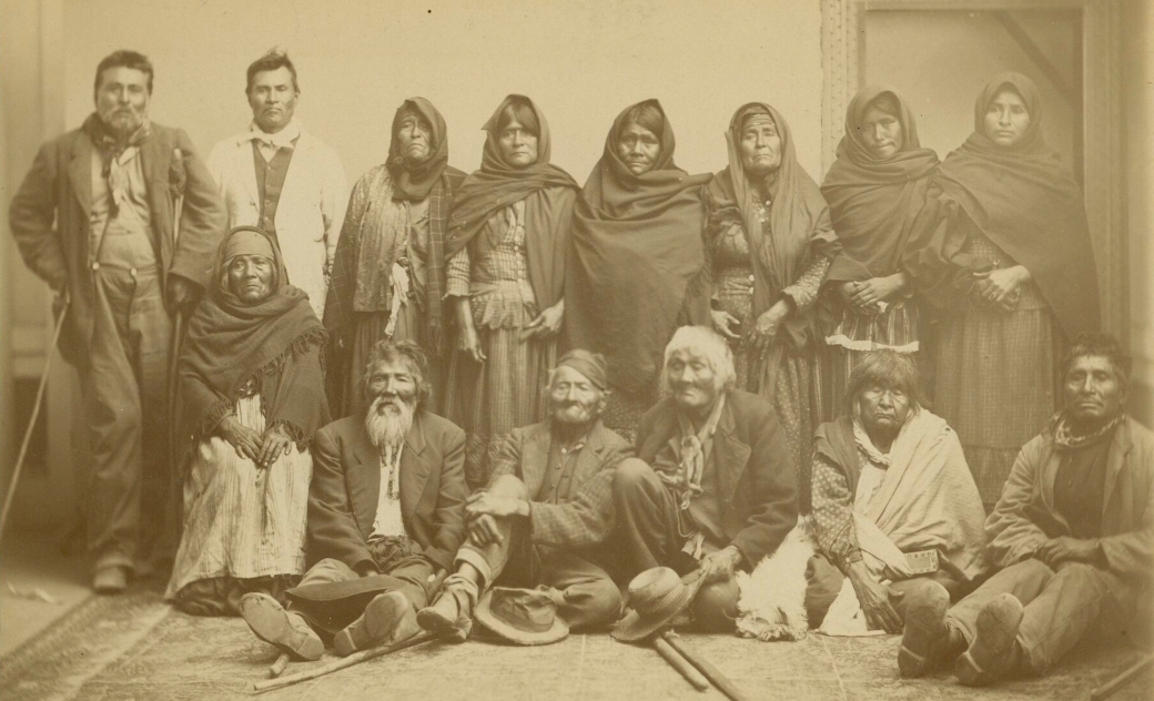
An Undated Photo of Kumeyaay Taken by Matilda Cox Stevenson. This is part of the Smithsonian Institution collection.
The Kumeyaay at the Dawn of The Twentieth Century
In her Ph.D. thesis for U.C. Riverside, Strategies for Survival: Indian Transitions in the Mountains of San Diego County, 1846-1907, p. 217, Dana Ruth Hick Dunn wrote the continuing battle for survival of the San
Diego Indians in the Twentieth Century:
By the late nineteenth and opening of the twentieth centuries, physical survival for Indians remained unstable. Non-Indians had taken most former Indian lands and compromised the traditional economies of the Iipay, Luiseño, Diegueño and Cupeño. Indians on reservations either farmed, ranched and utilized local plants and animals for subsistence or worked on American ranches and in the cities. Cultural continuity remained strong in the mountains of northern San Diego County. Though some ceremonies began to disappear, the language, basket culture, song cycles, communal gathering, healing, ceremony, morals in child raising, daily living and family life remained culturally strong.
The 1903 Forced Relocation of the Cupeños and Others
On May 13, 1903, the Cupeño (or Kuupangaxwichem) – neighbors of the Kumeyaay – were forcibly transported to the Pala Reservation by Indian agents in a three-day “Trail of Tears” and settled among the Luiseño people. The Cupeños were forced to move 75 miles away from their home near Warner Springs. The forced relocation to the Pala reservation also included "the Luiseño villages at Puerta la Cruz and La Puerta, and the Kumeyaay villages at Mataguay, San José, and San Felipe." It was described by historian Phil Brigandi as "the last of Indian 'removals' in the United States, ending a federal policy of forced relocations that had begun 75 years earlier.[34]
In 1905, it was revealed that all the federal treaties negotiated with the California tribes in 1852 were never ratified. This information became more widely known, prompting sympathy for the plight of the California tribes.
The Kumeyaay in 1910
In 1910, a Government Publication entitled, “The Indian Population in the United States in 1910,” stated that there were 755 Diegueno (Yuman-speakers) Indians. By this time, the Office of Indian Affairs (later Bureau of Indian Affairs), had surveyed the land identified by the Smiley Commission and issued trust patents for some of the land to be held for the respective bands. Scattered small, displaced Kumeyaay bands did not have lands reserved. The intention was that they should move onto larger reservations.
On July 1, 1910, San Pasqual Reservation was officially established under the authority of the 1891 congressional act. An Executive Order issued on April 15, 1911, set aside land for the reservation site, with an annex in 1972. Then in 1912, a small reservation was created for San Diego's Jamul Band of Mission Indians when the San Diego Diocesan Office of Apostolic Ministry deeds 2.34 acres to create the Jamul Indian Village. Four acres were later added by donation from the Daley Corporation, giving the Jamul Reservation a total of 6.2 acres.
The Jamul Band of Mission Indians Finds Success
On May 9, 1981, the Jamul Band obtained reservation status. Up to that time, electricity, telephone service, and running water were still not available. But, after the enactment of the Indian Gaming Regulation Act in 1988, the Jamul Indian Village announced their intention to build a casino. By 2022, the Jamul Indian Village was able to purchase 160 acres of its ancestral land in Jamul for expansion of the tribe’s land base to include residential housing for its members, health services, government operations, and additional non-gaming enterprises.[35] Today, the Jamul Casino, owned and operated by the tribe, is a well-known destination for many people. Starting with very little land in 1912, the Jamul Band eventually found great success.
The Kumeyaay Gain U.S. Citizenship (1924)
In 1924, the Kumeyaay people and all Native Americans of California gained U.S. citizenship via the Citizenship Act of 1924. However, While the Indian Citizenship Act granted official U.S. citizenship, California Indians still faced systemic disenfranchisement and were barred from voting in local elections. Native Americans did not get the full right to vote until 1952, at which time they were able to vote for local politicians.
Meanwhile, between 1919 and 1924, Kumeyaay leaders were actively protesting the plans of the San Diego City Council to locate a dam at the Capitan Grande Reservation. Legal resistance managed to stall the project for a few years, but eventually the City of San Diego succeeded in taking the reservation land in the 1930s to build the El Capitan Dam and Reservoir Community Location.
The agricultural economy of Kumeyaay Indians living on ancestral lands on the Capitan Grande Reservation — already diminished by a city diversion of the San Diego River to Lake Cuyamaca — suffered greatly after residents are forced off their lands to make way for the city of San Diego's El Capitan Dam and its reservoir. The forced displacement of Kumeyaay Indians from the Capitan Grande Reservation caused the bands to split into two groups. One band purchased land in Barona Valley to establish the Barona Band; the other group pooled their resources to purchase land in the Viejas Valley. But these two new areas proved to be too dry for a renewal of traditional farming livelihoods.
Barona Reservation: An Eventual Success Story
In 1932, without a homeland but with some federal monies allotted from the earlier sale, a group of the Capitan Grande Tribal members purchased the Barona Ranch which today is the Barona Indian Reservation near Lakeside, about 30 miles northeast of San Diego. For many years living without electricity, telephone service, and running water, the tribal members tried to create a living through ranching and farming. Until the early 1990s, the Barona Tribe was still struggling economically in the backwoods of San Diego. However, in 1994, the tribe opened the Barona Casino “Big Top,”and this property eventually became the world-class Barona Valley Ranch Resort and Casino.[36]
The Viejas Band of Kumeyaay: Another Success Story
Today, membership in the Viejas Band of Kumeyaay is determined by direct descent from the families forced from Capitan Grande who pooled their shares of the dam site purchase money to buy Viejas Valley. The Viejas continue to share a joint-trust patent with the Barona Band for the 15,000 acres remaining as the Capitan Grande Reservation. Currently, some 281 persons call the Viejas Reservation home. Their seven-year expansion project of the Viejas Casino & Resort was completed in October 2018 and has been an important source of revenue for the small Veijas Band.[37]
The 1928-1933 California Indian Census Count
The Act of May 18, 1928 (45 Stat. L., 602) stated that if an Indian who was residing in California on May 18, 1928, can prove that he or she is descended from Indians who were residing in California on June 1, 1852, they should be recorded. Agents of the Mission Indian Federation spread out across San Diego enrolling people who would receive payment for the California Judgment Fund.
The recipients had to fill out a six-page application answering various questions about themselves, their parents, grandparents, and children. At the end of the application was an affidavit that had to be signed by two witnesses. Initially, people had to complete the forms by 1930, but later the time to fill out the application was extended to 1932.
The National Archives files include two California two census rolls taken in 1928 and 1933. The rolls list each person’s name, address, date of birth, and address. The rolls are also sometimes referred to as base rolls (National Archives Identifier: 27753207). The number of people claiming Indigenous ancestry from the Kumeyaay bands in the 1928-1933 enrollment were:
Santa Ysabel (267)
Mesa Grande (240)
Mission Capitan Grande (146)
San Pasqual (120)
Mission Campo (106)
Mission Manzanita (83)
Mission Inaja (27)
Sycuan (48)
La Posta (5)
Jamul (4)
At the following link, the Indians Qualified under Section 1 of the Act of May 18, 1928 in the State of California can be seen. You can search this database for persons affiliated with the above-mentioned reservations at Ancestry.com’s California, U.S., Index to Census Roll of Indians, 1928-1933 search screen:
https://www.ancestry.com/search/collections/61006
You can also download the 499-page National Archives document here:
https://catalog.archives.gov/id/27753207
An excerpt of parts of two pages showing persons surnamed Scholder who identified themselves as being from the Mesa Grande tribal group follows:
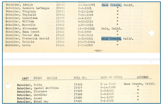
The 1928 Census List of Qualified Indians from Mesa Grande.
The Kumiai Population in Mexico
The first Mexican Census took place on October 20, 1895. In this first census, Baja California recorded 2,181 speakers of indigenous languages, which were spoken by several different tribal groups, as noted in the following table:
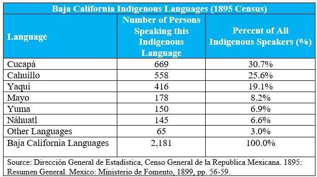
Mexico’s Indigenous Languages Spoken in Baja California in 1895.
The 1895 census tallied 558 Cahuillo speakers. It has noted that the term "Cahuillo" was previously applied to Indians living near Ensenada, Baja California. The linguist Kroeber has stated that the Cahuilla language was actually a dialect of Diegueno, who are today called Kumeyaay or Kumiai.[38]
The Kumiai at the Turn of the Century
By the time of the 1990 Mexican Census, there were only 95 Kumiai speakers left in the State of Baja California. Other Baja Indigenous linguistic groups had also declined, but only two tribal groups, the Cucapá (48) and the Kiliwa (28), had smaller numbers of people who spoke their languges.[39] Estimates of the actual Kumiai population in Mexico at the end of the Twentieth Century had put their numbers at 600, most of which could not speak the language. This population primarily occupied four rural communities with a total land base of more than 38,500 hectares.[40]
The 2000 census recorded 159 persons five years of age and older who actually spoke the Kumiai language in the state, and all but 13 of these also spoke Spanish and were thus bilingual. Sixty-six of Kumiai speakers in Baja California lived in the Tecate Municipio adjacent to the U.S. border. Smaller numbers of the Kumiai tribe lived in ranches within the municipios of Rosarito and Ensenada. During the Twentieth Century, the Kumiai were able to develop diversified economies that include cattle ranching, agriculture, handcraft production, seasonal wage labor, and natural resource use.
The Kumiai in the 2020 Mexican Census
In the 2020 Mexican census, there were 488 Kumiai speakers tallied in the State of Baja California.[41] However, most estimates of their population have varied between 600 and 1,200 Kumiai Indians living in the state. It is believed that most of them do not speak the Kumiai language, and most linguists suspect that fewer than 100 individuals are fully fluent speakers. Most of the Kumiai in Baja live in four traditional rural communities: San Antonio Necua, La Huerta, Juntas de Nejí, and San José de la Zorra.
The Kumeyaay Indian Gaming Begins
In 1983, the Sycuan Indian Reservation opened the first gaming center offering bingo games. By 2000, their facility had expanded significantly, and new types of gaming were offered. In 1984, the Barona Band built a bingo hall and also initiated gaming on their reservation. In 1991, the Viejas Reservation also started a gaming operation. Then, in 1988, Congress enacted the Indian Gaming Regulatory Act to bring tribal gaming under a regulatory structure and to give state governments added control over the types of casino-style games allowed on reservations. This law, signed by President Ronald Reagan on October 17, 1988, legalized gambling operations for federally-recognized Indian tribes in the United States and led to a new and lucrative source of revenue that would change the lives of many Kumeyaay.
The Kumeyaay (Diegueño) in the 1990 Census
According to the U.S. 1990 Census of Population Characteristics of American Indians by Tribe and Language, the total population of the Diegueno in the United States was 2,249, which was distributed as follows across the various reservations:[42]
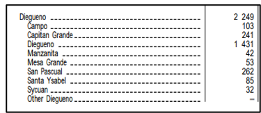
The Diegueno in the U.S. 1990 Federal Census.
U.S. Bureau of Census, 1990 Census of Population: Characteristics of American Indians by Tribe and Language, Section 1 of 2 (U.S. Department of Commerce, 1990), p. 7
San Diego County’s Native American Reservations Today
The 2019 San Diego Integrated Regional Water Management Plan produced its updated “Tribal Nations of San Diego County” Report in August 2018.[43] The report stated that “San Diego County features the largest number of Tribes and Reservations of any county in the United States. There are 18 federally-recognized Tribal Nation Reservations and 17 Tribal Governments, because the Barona and Viejas Bands share joint-trust and administrative responsibility for the Capitan Grande Reservation.” These San Diego Reservation lands that were governed by Tribal Nations totalled approximately 127,000 acres, or 198 square miles of the 4,205 square miles that make up San Dieg County. This report provided updated information on all the San Diego Reservations, 13 of which were Kumeyaay Reservations. The locations of the Tribal Reservations are presented in Figure 4-1 and summarized in Table 4-1. [44]
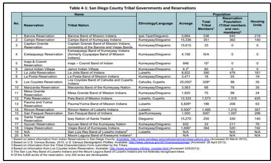
San Diego County’s Tribal Governments and Reservations (2019)
Source: 2019 San Diego Integrated Regional Water Management Plan, “Tribal Nations of San Diego,” (August 2018), page 4-3, Figure 4-1, “San Diego County Tribal Governments and Reservations.”
Reservations of Southern California
The following map from the Environmental Protection Agency shows all the reservations and tribal lands from the Southern California area, primarily encompassing three counties: San Bernardino, Riverside, and San Diego counties. In Southern California, there are currently four Native American reservations in San Bernardino County, 11 in Riverside County, 17 in San Diego County and one in Imperial County.
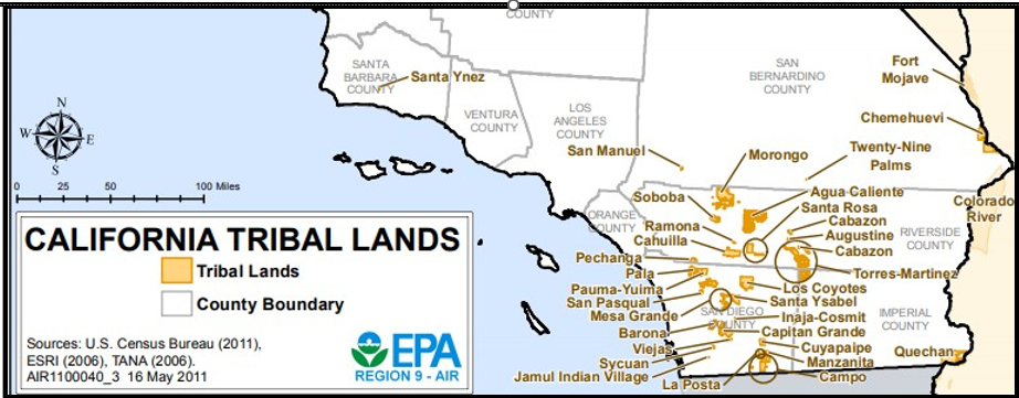
California Tribal Lands, Circa 2011.
Source: U.S. Environmental Protection Agency, “California Tribal Lands and Reservations.”
Indigenous California in the 2020s
There are 109 tribal nations in 34 counties of the State of California — more distinct tribes that in any other state. Most of the counties in the north have scattered reservations in several counties. California also has the largest Native American population in the country, with about 12% of the total Native American population as of the 2020 census. Based on U.S. Census figures in 2022, 1.7 percent of the California State population is American Indian or Alaska Native. [As of 2011, there were 565 federally-recognized tribes in the entire U.S].
Indigenous California and the Gaming Industry
On July 31, 2025, the National Indian Gaming Commission (NIGC) announced Gross Gaming Revenues (GGR) of $43.9 billion for fiscal year 2024. This historic figure reflects a $2.0 billion increase over FY 2023, representing an overall growth of 4.6% across the Indian gaming industry in the United States. The data was calculated from independently audited financial statements from 532 independently audited gaming operations owned by 243 federally recognized tribes across 29 states.[45]
California is the nation's largest Indian gaming state in the nation with total revenues of $9 billion annually. In 2000, California voters passed Proposition 1A which permitted casino-style gaming on tribal land in accordance with the existing gaming compact between an individual tribe and the state. Using 2022 figures from the National Gaming Commission, the Indian gaming website “500 Nations” stated that says 73 California tribes operated 76 casinos and five mini-casinos. In fact, casinos are found in 27 of California’s 58 counties. Non-casino tribes receive a share of casino revenues through the state-managed Indian Gaming Revenue Sharing Trust Fund (RSTF).
Indian Gaming in the San Diego County
San Diego County has the largest concentration of Indian casinos in the nation. Gaming has allowed Indian tribes to pursue the policy of self-determination, which means that Indian tribal governments can conduct their own affairs and manage their own finances. Today, forty-five percent of all California slot machines are located in Riverside and San Diego Counties. Ethan Banegas, in a 2017 article, has written extensively about the Kumeyaay casinos and their evolution in the last few decades.[46]
With more Indian reservations (19) and Indian casinos (9) than any other county in the United States, San Diego County is arguably the “Indian Casino Capital” of the world. Included among these casinos are several casinos owned by the Kumeyaay Nation, which operates the following:
Sycuan Casino Resort: Owned by the Sycuan Band of the Kumeyaay Nation, located in El Cajon. It features a luxury hotel, spa, and multiple dining options.
Viejas Casino & Resort: Owned by the Viejas Band of Kumeyaay Indians, located in Alpine. This includes extensive gaming floors, off-track betting, and luxury hotels.
Barona Resort & Casino: Owned by the Barona Band of Mission Indians, located near Lakeside. This resort is known for its golf course and ranch-style resort atmosphere.
Jamula Casino Resort: Owned by the Jamul Indian Village of California, located about 20 miles east of downtown San Diego. This resort includes a luxury 16-story hotel tower and a 23-story rooftop pool deck.
Golden Acorn Casino: Owned by the Campo Band of Diegueno Mission Indians (Campo Kumeyaay Nation) off Interstate 8 in Boulevard.
San Pasqual Valley View and Casino: Opened in 2001, this casino is owned by the San Pasqual Band of Mission Indiand and features over 2,000 slot machines, 21 table games, a boutique hotel, and several dining options. It is located in Valley Center, 40 miles north of San Diego.
The following Kumeyaay produced map shows the locations of the Southern California Indian Casinos and Resorts in 2025.
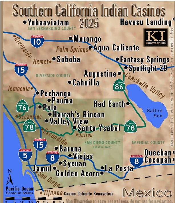
A Kumeyaay Map of the Southern California Casinos and Resorts (2015)
Source: Kumeyaay, “Best Indian Casino Gambling Guide.” Online: https://www.kumeyaay.info/san_diego_indian_casinos/ [Accessed 07/07/2026].
These properties, including hotels, dining, and entertainment, generate over $9 billion annually in the statewide native gaming industry. Looking back at the Smiley Commission Report in 1891 [discussed earlier in this report], there is a major contrast in the condition of the Kumeyaay then and the Kumeyaay now.
The Kumeyaay Are Triumphant Today
Considering their long-running battle for land in San Diego County, the Kumeyaay are triumphant today. There are 13 Kumeyaay reservations in San Diego County, plus four tribal villages [ejidos] in northern Baja California, Mexico, for a total of 17 Kumeyaay reservations. One of the largest owners of land in San Diego County, Kumeyaay governments have jurisdiction over approximately 70,000 acres concentrated in the East San Diego County from El Cajon, Lakeside, Poway and Ramona to the desert.
Kumeyaay economic activities in San Diego center on tribal enterprises, retail, hospitality, and cultural preservation. Gaming is a primary revenue source, funding tribal government services, housing, and healthcare, with a significant economic footprint that provides tens of thousands of regional jobs. Cody J. Martinez, writing in The San Diego Union-Tribune [March 27, 2016] explained how the gaming industry has helped the Kumeyaay and other San Diego tribal groups to invest in other services:
For many tribes, gaming has been the foundation upon which broader economic and social progress has been built. It has enabled tribal governments to invest in essential services — health care, education, housing and infrastructure — that many communities had long been denied. Just as importantly, the success of tribal gaming has extended beyond reservation boundaries, supporting regional economies, creating jobs, and fostering partnerships that benefit both tribal and non-tribal communities alike… True sovereignty means not only building success but sustaining it. That is why we have worked to diversify our economic base, ensuring long-term stability for future generations. A clear recent example is our historic co-ownership investment in San Diego FC, the region’s Major League Soccer expansion team. This step reflects both our commitment to economic growth and our deep connection to the broader San Diego community. Equally important is our responsibility to give back. For generations, the Kumeyaay people have understood the value of community and stewardship. Today, that tradition continues through our support of nonprofit organizations and community initiatives that strengthen the fabric of San Diego. We believe that when one part of our region thrives, we all thrive.
The Blood of the Band: An Ipai Family Story
David L. Toler, Jr., wrote The Blood of the Band: An Ipai Family Story in 2015 (published by Sunbelt Publications in San Diego and sold on Amazon.com). In his dedication, Toler states the book is “a memorial to the original inhabitants of San Diego County, a testament to our peoples’ courageous spirits, their brave and continued resistance in the face of invasion and colonizing forces.” He wrote the book “as an acknowledgement of the stamina, resilience, and perseverance of our region’s native peoples.” The book reflects on the Kumeyaay history, the growth of the reservations, and family histories. In fact, Chapter 7 discusses family histories and testimonials of the La Chappa, Guachena, Nejo, and other clans. Chapter 8 is entitled “Genealogy: Who Are Your People,” in which he discusses 18 notable people among the Kumeyaay.
Primary Sources
Almstedt, Ruth Farrell. Bibliography of the Diegueño Indians. Ramona: Ballena Press, 1974.
Boulé, Mary Null. California Native American Tribes: Ipai-Tipai Tribe (Diegueño). Vashon, Washington: Merryant Publishers, Inc., 1992.
Brigandi, Phil. “In the Name of the Law: The Cupeño Removal of 1903.” The Journal of San Diego History (Winter 2018) 64 (1).
Carrico, Richard L. Strangers In A Stolen Land: American Indians in San Diego, 1850-1880. Sacramento, California: Sierra Oaks Publishing Company, 1987.
Carter, Nancy Carol. “Chronology of the Indigenous Peoples of San Diego County.” Online: https://www.sandiego.edu/native-american/chronology.php [Accessed 07/07/2026].
Coy, Owen C., Ph.D. The Battle of San Pasqual: A Report of the California Historical Survey Commission with Special Reference to its Location. Sacramento: California State Printing Office, 1921.
Heinzer, Robert F. The Eighteen Unratified Treaties of 1851-1852. Berkeley, California: Archaeological Research Facility, 1972.
Hick Dunn, Dana Ruth. Strategies for Survival: Indian Transitions in the Mountains of San Diego County, 1846-1907. Ph.D. Thesis, U.C. Riverside, 2013.
Hoffman, Geralyn Marie & Gamble, Lynn H.. A Teacher's Guide to Historical and Contemporary Kumeyaay Culture. Institute for Regional Studies of the Californias. San Diego State University, 2006.
Hyer, Joel R., “We Are Not Savages”: Native Americans in Southern California and the Pala Reservation, 1840-1920. East Lansing, Michigan: Michigan State University Press, 2001.
Kroeber, A. L. Handbook of the Indians of California. Bureau of American Ethnology Bulletin (78). Washington, DC., 1925.
Kumeyaay, “Kumeyaay Timeline.” Online: https://www.kumeyaay.com/kumeyaay-timeline.html [Accessed 07/07/2026].
Langdon, Margaret & Redden, James E. (ed.). “Diegueño: How Many Languages?". Proceedings of the 1990 Hokan-Penutian Languages Workshop. Carbondale, IL: University of Southern Illinois, 1990: pp. 184–190.
Logan Bourbois, Julia, The Complexities of Labor: A History of San Diego Indians, 1770-1920. Ph.D. Thesis U.C. Riverside, 2016.
Luomala, Katharine. "Tipai-Ipai". In Heizer, Robert F. (ed.). Handbook of North American Indians. Vol. 8: California. Washington, DC: Smithsonian Institution, 1978, pp. 592–609.
Mathes, Valerie Sherer & Brigandi, Phil, Reservations, Removal and Reform: The Mission Indian Agents of Southern California, 1878-1903. Norman, Oklahoma: University of Oklahoma Press, 2018.
McGrew, Clarence Alan. City of San Diego and San Diego County: The Birthplace of California. Chicago and New York: The American Historical Society, 1922.
Rushmore, Elsie Mitchell. The Indian Policy During Grant’s Administrations. Jamaica, NY: The Marion Press, 1914.
Shipek, Florence C. "History of Southern California Mission Indians". In Heizer, Robert F. (ed.). Handbook of North American Indians. Vol. 8: California. Washington, DC: Smithsonian Institution, 1978.
Toler, Jr., David L. Blood of the Band: An Ipai Family Story. San Diego: Sunbelt Publications, Inc., 2015.
Wiken, Michael Alen. An Ethnobotany of Baja California’s Kumeyaay Indians. Master’s Thesis: San Diego State University, 2012.
Footnotes:
[1] Philip R. Pryde (ed.), San Diego: An Introduction to the Region (Dubuque, Iowa: Kendall/Hunt Publishing Co., 1976), p. 5.
[2] Richard L. Carrico, Strangers In A Stolen Land: American Indians in San Diego, 1850-1880 (Sacramento, California: Sierra Oaks Publishing Company, 1987), p. 5.
[3] Margaret Langdon & James E. Redden (ed.), "Diegueño: How Many Languages?". Proceedings of the 1990 Hokan-Penutian Languages Workshop (Carbondale, Illinois: University of Southern Illinois, 1990), pp. 184–190.
[4] Katharine Luomala, "Tipai-Ipai" in Heizer, Robert F. (ed.), Handbook of North American Indians, Vol. 8 (California. Washington, DC: Smithsonian Institution, 1978), p. 592.
[5] A. L. Kroeber, "Handbook of the Indians of California". Bureau of American Ethnology Bulletin (78) (Washington, D.C., 1925), p. 88.
[6] Katharine Luomala, op. cit., p. 596.
[7] Viejas Band of Kumeyaay Indians of Kumeyaay Indians, “A Brief History.” Online:
https://viejasbandofkumeyaay.org/wp-content/uploads/2014/10/ViejasHistoryBooklet.pdf [Accessed 6/13/2026].
[8] Ibid.
[9] Richard L. Carrico, “Sociopolitical Aspects of the 1775 Revolt at Mission San Diego de Alcala,” The Journal of San Diego History, San Diego Historical Society Quarterly, Summer 1997, Volume 43, Number 3.
[10] Iris H.W. Engstrand, Serra’s San Diego: Father Junipero Serra and California’s Beginnings (San Diego: San Diego Historical Society, 1982), p. 11.
[11] Glenn Farris, “Captain Jose Panto and the San Pascual Indian Pueblo in San Diego County, 1835-1878,” The Journal of San Diego History, San Diego Historical Society Quarterly, Spring 1997, Volume 43, Number 2.
[12] Valeries Sherer Mathes and Phil Brigandi, Reservations, Removal and Reform: The Mission Indian Agents of Southern California, 1878-1903. Norman, Oklahoma: University of Oklahoma Press, 2018, p. 5; Richard L. Carrico, Strangers In A Stolen Land: American Indians in San Diego, 1850-1880 (Sacramento, California: Sierra Oaks Publishing Company, 1987), p. 46.
[13] Valeries Sherer Mathes and Phil Brigandi, Reservations, Removal and Reform, p. 5.
[14] Sherburne F. Cook, “The American Invasion, 1848-1870” in The Conflict Between the California Indian and White Civilization (Berkeley: University of California Press, 1976), p. 309.
[15] Sen Exec. Docs. 37 Cong., 2 Sess, Vol. 1, Doc. 1 (Series 1117) 757, 759.
[16] James J. Rawls, Indians of California: The Changing Image (Norman: University of Oklahoma Press, 1984), 96, citing Sherburne F. Cooke, “The Indian Versus the Spanish Mission,” reprinted in The Conflict Between the California Indian and White Civilization (Berkeley: University of California Press, 1976), pp. 57, 61; Edward D. Castillo, “The Impact of Euro-American Exploration and Settlement,” in Robert F. Heizer, California, vol. 8 of Handbook of Northern American Indians, ed. William C. Sturtevant (Washington, D.C.: Smithsonian Institution Press, 1977), 109.
[17] Carrizo, Strangers in a Stolen Land, p. 54.
[18] Ibid., p. 54.
[19] Ibid., page 54; U.S. Department of the Interior, Office of Indian Affairs, Annual Report of the Commissioner of Indian Affairs for the Year 1859, p. 6.
[20] Wilmington Journal, 13 May 1865, Richard L. Carrico, Strangers in a Stolen Land, pp. 55-56
[21] Richard L. Carrico, Strangers in a Stolen Land, p. 57.
[22] U.S. Department of the Interior, Office of Indian Affairs, Annual Report of the Commissioner of Indian Affairs to the Secretary of the Interior for the year 1875, p. 10; Richard L. Carrico, Strangers in a Stolen Land, pp. 60-61.
[23] Valerie Sherer Mathes and Phil Brigandi, Reservations, Removal, and Reform, pp. 10-11.
[24] U.S. Congress, House, Letter from the Secretary of the Interior Regarding Indian Reservations in San Diego County, House Executive Document 296, 41st Congress, 2nd Session, 1870, pp. 1-2.
[25] Richard L. Carrico, Strangers in a Stolen Land, p. 66.
[26] Valerie Sherer Mathes and Phil Brigandi, Reservations, Removal, and Reform, p. 11.
[27] Richard L. Carrico, Strangers in a Stolen Land, pp 83-84.
[28] Ibid., p. 84.
[29] Ibid., p. 84.
[30] U.S. Department of the Interior, Office of Indian Affairs, Annual Report of the Commissioner of Indian Affairs to the Secretary of the Interior, 1886, p. 307; Richard L. Carrico, Strangers in a Stolen Land, p. 89.
[31] Richard L. Carrico, Strangers in a Stolen Land, p. 89.
[32] Richard L. Carrico, Strangers in a Stolen Land, p. 92.
[33] An Act for the Relief of the Mission Indians in the State of California, 51st Congress, Session II, Chapter 65 (26 Stat. 712).
[34] Valerie Sherer Mathes and Phil Brigandi, Reservations, Removal, and Reform, p. 114.
[35] Phil Brigandi, "In the Name of the Law: The Cupeño Removal of 1903". The Journal of San Diego History. 64 (1) (Winter 2018).
[36] Jamul Indian Village, “Timeline.” Online: https://jiv-nsn.gov/timeline/ [Accessed 07/07/2026].
[37] Barona Band of Mission Indians, “Barona History.” Online: https://www.barona-nsn.gov/history [Accessed 07/07/2026].
[38] Kumeyaay, “Viejas Band of Indians.” Online: https://www.kumeyaay.com/viejas-band-of-indians.html [Accessed 07/07/2026].
[39] Bright, William, “The Origin of the Name ‘Cahuilla,’” The Journal of California Anthropology, Vol. 4, No. 1 (Summer 1977), p. 116.
[40] INEGI, XI Censo General de Población y Vivienda 1990. Tabulados Básicos: Población de 5 Años y Más Que Habla Alguna Lengua Indígena por Entidad Federativa y Tipo de Lengua Según Condición de Habla Española y Sexo.
[41] INEGI. Censo de Población y Vivienda 2020. Tabulados del Cuestionario Básico (Mexico, 2021).
[42] U.S. Bureau of Census, 1990 Census of Population: Characteristics of American Indians by Tribe and Language, Section 1 of 2 (U.S. Department of Commerce, 1990), p. 7. Online:
https://www2.census.gov/library/publications/decennial/1990/cp-3-7/cp-3-7-1.pdf [Accessed 07/07/2026].
[43] 2019 San Diego Integrated Regional Water Management Plan, “Tribal Nations of San Diego,” (August 2018). Online: https://sdirwmp.org/pdf/SDIRWM_04_Tribal_Nations_DRAFT_2019.pdf [Accessed 07/07/2026].
[44] Ibid., Page 4-3, Figure 4-1, “San Diego County Tribal Governments and Reservations.”
[45] National Indian Gaming Commission Bulletin, 31 July 2025. Online:
https://www.nigc.gov/nigc-announces-record-43-9-billion-in-fy-2024-gross-gaming-revenues/ [Accessed 07/07/2026].
[46] Ethan Banegas, “Indian Gaming in the Kumeyaay Nation,” The Journal of San Diego History: San Diego History Center Quarterly (Volume 63, No. 1, Winter 2017) at https://sandiegohistory.org/journal/2017/january/indian-gaming-kumeyaay-nation/ [Accessed 07/07/2026].